Snow Water and Predicting When to Take Your Trip
If you are getting excited about your summer fishing trip out west you might want to take a little time and do some checking on the snow water. The U. S. Department of Agriculture’s Natural Resources Conservation Services (NRCS) manages a program, know as Snotel, that keeps track of snow water at selected locations around the West. This data monitoring system in conjunction with the U. S. Geological Survey’s stream flow monitoring network is invaluable to STREAM SIDE ADVENTURES in planning our summer guiding schedule. Our 20 years of experience of evaluating these data sources has given us great insight and understanding of the Upper North Platte River Basis’s runoff cycle.
Don’t rush to conclusions when you hear about snow water from the weather reports. A blizzard on the front range near Denver may or may not have any bearing on how many people are “bellied up to the bar” waiting out the storm at Encampment, Wyoming’s Pine Lodge. Snow water can be very different from one location to another. You may have heard of a “rain shadow”, well there is a “snow shadow” as well.
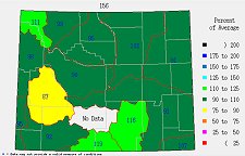 Using Wyoming as an example, here is a little bit about how to evaluate snow water. For the most part snow water over much of the Wyoming has been very good so far this year. Even for the Upper Green River Basin, which is the furthest behind the long term averages, a review of the individual Snotel station for the basin indicates that the that a major culprit in the basins overall average is the East Rim Divide station which is only 67 percent of average. What is the most important is where that station is in relationship to the other Snotel stations in the basin and where you might be planning to fish.
STREAM SIDE ADVENTURES’ primary basin of interest is the Upper North Platte River. There are 11 Snotel monitoring sites in the Upper North Platte River Basin. Six are located in Wyoming and the other five are in Colorado. Two of the Wyoming sites, Divide Peak and Sage Creek are located well downstream of the area we fish so have no bearing on predicting runoff levels. Four of the sites; Columbine, Old Battle, Tower, and Webber Springs monitor snow water within the Encampment River sub-basin. One site, North French Creek, monitors levels in the French Creek sub-basin and the remaining sites monitor levels in the North Platte River sub-basin above North Gate.
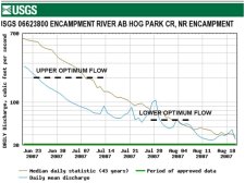 Looking at just the Encampment River sub-basin, the average snow water in the basin is 103 percent or just above the long term average. So what does that mean about the start of this summers fishing? Based on our 20 years of experience we know that the optimum flow levels for fishing the Encampment Rivers start at about 200 CFS and continue until the river falls below about 60 CFS. In years when the snow water levels are at or near the long term average, the river has fallen to the 200 CFS level during the second week in July. In years when the snow water are below the long term average, the Encampment falls to that 200 CFS level much earlier in the year.
 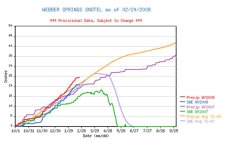 Conditions in 2007 are an excellent example. Snow water at Webber Springs, a Snotel station in the Upper Encampment River Drainage, was well below the long term average. The 200 CFS level was reached about two weeks soon than normal. Based on the year to date snow water level at Webber Springs, the 200 CFS level will likely be reached a few days later than for a normal year.
Of course nothing is as simple as it seems. A decrease in snow depth due to temperature variations effects the equation. If the temperatures warm for a few days, some of the snow will melt and fill the spaces within the snow pack. Later, often overnight, when temperatures fall below freezing, the melted snow water will re-freeze and compress. A block of ice melts slower than crushed ice and a compressed snow pack melts slower than an uncompressed snow pack. And of course, you have to have some idea of what water level the runoff has fallen to a fishable level.
Ask a local fly shop about optimum water levels and then start poking around these two sites for the information you need:
https://www.wcc.nrcs.usda.gov/snow/ for snow data
https://waterdata.usgs.gov/nwis/rt for stream flow data