Stream Flow And Fly Fishing: How A Stream Gage Works
You walk into just about any fly shop in the world and there are two things you can damn near bet will be on the “fishing board”; one will be olive wooly buggers is the one of the recommended flies. The other thing will be a listing of the stream flow in CFS. What exactly does it mean? In the case of the wooly bugger it means that it is a sure fire fly any time and any place. In the case of stream flow it means that some number of Cubic Feet of water is flowing past some point each Second. The wooly bugger part is simple to understand but how about the CFS part?
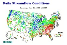 We here in the US are very lucky to have a wide ranging system of “stream gages” to measure the flow of water around the country. Most of these gages are operated by the US Geological Survey (https://waterdata.usgs.gov/usa/nwis/rt).
While not every stream has a gage, a great number of them do, especially those that are important for flood prediction, irrigation in the west, recreational or some other special need. And, now almost all these gages are what are known as “real time”. A real time gage makes a measurement every 15 minutes and transfers the data via a satellite link to a central computer where the public can access the measurement!
The number of CFS (Cubic Feet per Second), commonly referred to as the stream discharge, is a measure of the volume of water passing a point each second of time. The value is determined by multiplying the cross sectional area of the stream, in square feet, times the speed or velocity of the water, in feet per second. Sound simple and it is, but being simple doesn’t mean it doesn’t involve a little time and effort.
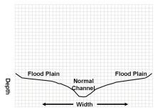 Once a suitable location for the gage has been determined, stream channel measurements have to be made. Natural stream channels are not smooth and don’t have a clearly symmetrical geometric shapes. They vary in depth from place to place across the stream and from one cross section to another on the stream. But most all stream channels do have some degree of similarity. Most have a generally “U” shaped channel with a somewhat flat bottom and relatively steep sides. This is the channel area for normal flows. Above this normal channel is the flood plain, a wide area with relatively flat sides terminating at steep sides. This combination of both a normal and flood channel has a strong impact on what the river is like during high and low flow periods.
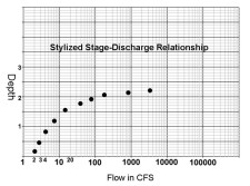 As the river starts to raise, the deep of the river increases rapidly within the normal channel, accompanied by a marked increase in discharge. This is because in a “U” shaped stream channel, there is very little increase in channel width to correspond to the increase in depth. However once the flow in the river is sufficient to reach the flood plain, there is a large increase in width for relatively small increases in depth. Hydrologists develop what they call “Stage –Discharge” relationship to show these changes. Once this relationship is developed, all we need to know is the depth of the water to know what the discharge is.
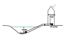 Modern stream flow gages are now highly automated. The typical gage consists of a gage house that houses the data collection equipment, a connection to the stream and a power source. Most also have a staff gage – similar to a ruler – to manually measure the gage height.
To measure the gage height and thus know what the discharge is, an air pump located in the gage house pumps a small bubble of air into the river via a permanent pipe. The depth of the pipe’s outlet is at a fixed depth known as the “datum”. This datum is generally not at the bottom of the stream but is generally very near to bottom. The distance between the datum and the water surface is what is reported as the gage height. The pressure required to pump the air bubble out through the pipe is directly correlated with the gage height which is the depth basis for the stage – discharge relationship. A small micro processor within the gage house makes the necessary calculations and up links the information to a central processing station via satellite. All we have to do is connect to the gage via the internet and we can see if the river level is rising, falling or steady.